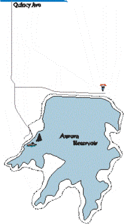
And where does the water come from? The creeks seems inadequate to keep this basin filled. The answer: Runoff from high altitude mountain snowpack is diverted through a series of storage reservoirs, natural streams, pipes, and tunnels up to 180 miles to this high plains waterhole. This accounts for its cold and sparkling blue appearance.
A bike path circles the lake, providing access to areas not served by roads. For the most part it stays close to the shoreline. The land here is not flat, but this is not a strenuous ride. Hills are shallow or short, or both. Do not expect any shade -- this is classic prairie landscape, with few trees. Besides the endless sere hills, views from the east side include the backdrop of the mighty Rockies.
Access to the park generally means paying a day-use ($4.00 in early 2001) or season-pass fee, and parking at the reservoir. You could bike in, but there are no places nearby to stow a car. The only option is to cycle for miles on busy Quincy Ave. (The park is located two miles east of E-470.)
The bike path runs 8.0 miles around the lake. (Disregard the ‘8.5 mile bike path' listed on old park pamphlets. A shortcut, installed to bypass a stretch running beside the park road, shortened the loop.) Though you can park at the base of the dam, most people park at the swim beach, an area also housing the general store, concession stand, and park offices. Thus, I will list mileages starting at the entrance to the boat parking lot, running clockwise around the park.
Start off on the concrete sidewalk running along the park road, passing by the dry boat storage. At your first opportunity (mile 0.1) turn right onto the concrete path labeled ‘authorized vehicles only' (this means no motorized conveyances). The sidewalk continuing alongside the road is the ‘old' path, which joins our path again at the dam.
You now have a shallow climb through the prairie, cresting at mile 0.3 to an expansive view of the reservoir. The path now runs a bit above the lake, heading for the dam. When the old path merges again with ours (0.7), the surface turns to asphalt. Follow it across the dam, passing above the dam parking at the far end (1.5).
On the east side, the trail follows fairly close to the lake, running along the serrated shoreline. There is little to interrupt the eye besides three unisex bathrooms offering respite if Mother Nature makes a call. Look for wildlife. Checklists you can pick up at the general store identify species that live in the park -- 30 reptile and amphibian, over 50 mammals, and more than 310 bird species.
You'll pass the southern end of the lake at Lone Tree Cove (4.2). Now ‘fitness trail' stops and interpretive signs dot the trail. Stop and read about the natural world you're passing through! Many signs talk about the winged visitors, including numerous hawks, shorebirds, and even an occasional bald eagle. Others mention the fish, mammals, or vegetation. (Did you know that Colorado has an official State Grass? Did you know that it's Blue Grama Grass?)
Next up are the scenic views of Senac Cove. In the lake, submerged in waters dozens of feet deep, giant trees spread their dead branches skyward. When the dammed waters filled the cove, the majestic trees that thrived there drowned but did not fall. (When officials first planned the reservoir, they nearly named it Senac Reservoir).
Continue following the asphalt ribbon over the rolling hills. Soon you'll top a rise (6.4), and see the distinctive blue roofs and white fences of the swim beach complex across another cove. You still have another swing around that cove before you're finished. At the edge of the complex (7.6), the trail surface once again becomes concrete. Watch your speed here (or better yet, dismount), as this is the park's most crowded area. Once through this area, follow the path back to the boat parking area (8.0) to complete the loop.
