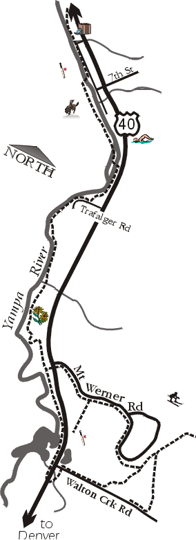
Follow the trail across 5th St (0.8) and through a tunnel onto an island splitting the Yampa River. The lush island is over quickly, and a bridge dumps you back onto the east bank. On hot summer days the traffic under the bridge is heavier than that on the trail, with inner tubers floating down the stream. Several outfitters in town rent tubes, shuttling floaters upstream to the put-in.
The next short stretch stays semi-wild, with no road crowding the trail. At 1.6 miles the trail turns right onto Trafalger Dr, but promptly turns back onto the path. After passing a few houses the trail runs along the edge of a new park, with ballfields and soccer fields for organized sport. Across the river, forested slopes provide a green background. Noise from the river hides the sound of traffic from the never-distant US40.
If you have time, stroll through the botanic gardens (2.2). A new attraction adjacent to the trail, it has walking paths, a pond, and several theme gardens. Ahead on the trail lies the Fish Creek modular homes, then by a lumber yard, fishing pond, and more native flora.
By the time you reach the Mt Werner Rd (3.3), the steep slopes to the west have become rolling hills. Hills to the east now grow steeper, marking the ski area. Continue straight past the tuber's put-in, running between the river and the highway.
The trail passes under US40 at mile 4.1, and then splits. To the right the path crosses a bridge before turning to gravel and ending at mile 4.6. (Plans are underway to extend this leg a bit further.) Instead, head left, cross Walton Creek Rd, and pass by Casey's Pond to reach more softball fields. Past the field the path reforms on your left and takes you to Mt Werner Rd (4.7).
Time for another decision. If you wish to return now to Lincoln Park, take the path to the left. It follows the road back to Mt Werner Rd stop sign after passing under the highway (5.2). To explore the base of the ski area, turn right instead. Follow the sidewalk trail uphill to mile 5.2, and stop to enjoy the view. Below you the tennis center, open fields, and a much-photographed barn spread out at the base of the hill.
At Eagle Ridge Dr the trail leaves the road, dropping quickly to the Village Center. Another junction greets you at mile 5.4, providing more options. You may go left, then turn left on Village Dr, and right on Apres Ski Ln to reach another paved path between condos. A left here takes you to the mountain gondola offering sightseeing rides during the summer. A right on this path takes you on a short climb behind condos and fields, ending at Walton Creek Rd (5.8). Turn right here to go down Walton Creek Rd, reaching Eagle Ridge Dr/Whistler Rd at mile 6.1.
If you took a right turn at the junction at mile 5.4, the trail follows the creek down Eagle Ridge in front of a large condo complex. It merges with the path in the above paragraph when it reaches Walton Creek Rd (5.7), saving you nearly a half-mile. Follow Walton Creek Rd down another 0.3 miles to reach Casey's Pond, and then choose which route to return on.
